How San Diego is waiving fire code in one of the county’s riskiest wildfire areas to upzone large developments
How San Diego is waiving fire code in one of the county’s riskiest wildfire areas for an upzoned housing development
The Santa Ana winds, blowing hot, dry air from the desert, accelerated the Cedar fire’s advance by throwing burning embers hundreds of feet. At one point the fire jumped 12 lanes of Interstate 15. It was so hot it melted asphalt.
California’s fires are only getting worse, yet San Diego County is giving a proposed housing project an exception to fire code meant to ensure safe evacuation. Examining this code waiver and what it could mean for my family during the next wildfire.
The context
West of the city of Escondido and south of San Marcos is the small, rural community of Harmony Grove. Bordered by the Elfin Forest Recreational Reserve and Del Dios Highlands Preserve, hikers can look down on the chaparral covered hills that surround the valley and its existing homes.
Rated a Very High Fire Hazard Severity Zone by CAL FIRE, since 1980 there have been 19 wildfires within three miles of the valley. Meaning, Harmony Grove should expect to be threatened by a wildfire every 2 years on average.
Santa Ana wind driven fires typically begin east of the area and travel through Harmony Grove, to threaten Elfin Forest, San Marcos, Encinitas, Escondido, Carlsbad, Rancho Santa Fe, and other communities nearby. 36 structures in Harmony Grove were completely destroyed in 2014’s Cocos Fire.
My grandparents built their home in Harmony Grove in 1967. The home survived the Del Dios Fire of 1997, although everything else on the property burned. The house itself only remained standing because after the firestorm passed, my grandfather, father, and two of his brothers, were able to run back up the hill and put out the fires burning on the deck and the roof.
When housing development is king
Escondido Creek, which begins above Lake Wohlford, trends southwesterly through the community, eventually flowing into the San Elijo Lagoon. The main roads are Country Club Drive and Harmony Grove Rd, two-lane country roads that are popular weekends routes for cyclists. South of the intersection where these roads meet, Country Club Drive crosses the Escondido Creek to arrive at the proposed site of a controversial new housing development, Harmony Grove Village South (HGVS).
Although the plot of undeveloped land is only zoned for 25 homes, HGVS is planned as a 453 home subdivision. The development is backed by Colorado-based Real Capital Solutions, the real-estate firm of billionaire Marcel Arsenault who made a fortune during the 2008 housing crash.
Per state law, the county created a General Plan seven years ago to accommodate the region’s projected population growth. This plan is a blueprint to guide where, and how much, new housing can be built in unincorporated areas like Harmony Grove. The General Plan steers future growth toward city centers and away from areas without adequate water, road and fire services.
Arsenault and his team purchased the land knowing the General Plan only allowed for 25 houses, but are making a bet that the developer-friendly San Diego County Board of Supervisors will re-zone the land for their project.
It’s a pretty good bet.
10,000 homes
The Board of Supervisor’s willingness to go along with the desires of housing developers is on full display this summer. The supervisors are expected to approve seven housing developments, totaling more than 10,000 units, and each far exceeds the number of homes allowed under current zoning laws.
Each housing development will require an amendment to the General Plan.
A law passed in 1984 aimed at maintaining the integrity of General Plans limits counties to four such amendments each year. In a brazen dismissal of the spirit of this law, the county is employing a legal loophole, a seldom-used provision that allows supervisors to “bundle” the developer applications. In response, county residents have started a voter ballot initiative to take away the Board of Supervisors ability to overrule the General Plan, giving this decision to San Diego voters instead.
The building industry and developers say the projects are needed now to address the region’s housing crisis. Pam Slater-Price, who served on the Board of Supervisors from 1992–2013, recently wrote an opinion piece for the U-T and rebutted:
“Deep-pocketed developers present a false choice, that the only way to get a roof over every head is to build sprawl-style developments in the middle of the countryside, where they’ve purchased land on the cheap with the hope of building it up for a handsome profit.
Developers purchasing land designated for low-density uses intending to build large developments are essentially speculators. Unfortunately, the county has repeatedly rewarded this speculation. A series of proposals for developments remote from transit and other services are currently awaiting county approval, including Newland Sierra, Harmony Grove South, Valiano and Warner Ranch. Lilac Hills Ranch — roundly defeated by voters in 2016 — will likely be revived.”
Of the half dozen (or more) development projects coming before the Board of Supervisors this year, this week’s hearing for HGVS is special. It includes an unprecedented fire code exception that dramatically increases the likelihood of residents becoming trapped during the next wildfire.
Dead End Road
Country Club Drive is a single access, two-lane winding country road that crosses the Escondido Creek and eventually dead-ends 1.7 miles from the creek crossing. Today, sixty homes rely on Country Club Drive as their only exit from the area.
When a wildfire threatens developments accessible by one dead‐end road, potentially life threatening problems arise getting residents out and emergency first responders in. Even if access is not blocked by the fire itself, factors such as inadequate road widths, steep grades, presence of obstacles, etc., can interfere with safe/timely movement, causing entrapment of residents and the inability of responders to do their job.¹
Considering the deadly consequences of becoming trapped during a wildfire, the County of San Diego Consolidated Fire Code and the California Code of Regulations sets maximum lengths for dead-end roads. By putting forward a plan of 453 units with parcels of less than 1 acre, the HGVS development is subject to a dead-end road length of 800 ft max. A second means of access is required if this maximum dead-end road length is exceeded.
HGVS has a dead-end road of 4224ft, over 5 times the maximum allowed length and the developer has no plans for a secondary exit. For existing residents, like my family positioned towards the dead-end, they are an alarming 11x the recommended distance. So the question is, why isn’t the developer providing the required secondary evacuation route?
Square Peg, Round Hole
The developer of HGVS claims, “steep topography, wildland fuels, environmental issues, roadway distance to acceptable connections, and private ownership/easements” made a secondary exist infeasible.
The fire code isn’t something you throw out because logistical or financial constraints made it inconvenient.
The General Plan is the result of $18 million in taxpayer-funded studies and 13 years of work. The developer’s excuses for not meeting the bare minimum of fire safety are just proof that the General Plan correctly zoned the land in the first place. Environmentally the area is not meant for a large subdivision. But the developer wants the profit to be gained from forcing 453 homes into that space, without footing the bill for the corresponding additional infrastructure.
Fantasy Planning
Fantasy planning is a term researchers use for emergency planning that relies on best-case scenarios —assuming calm seas for several days following an oil spill — which serve to persuade and soothe the public. Sometimes the plan is symbolic. Simply by going through the planning process the organization is offering the illusion of safety and control during future disasters, despite logical fallacies in the plan. When constructed well, these imaginative scenarios are essentially dreams created from the promised credibility of the organizations producing them.²
In their Fire Protection Plan and HGVS Evacuation Plan, Arsenault and Real Capital Solutions have engaged in such fantasy planning. Their plans objectively do not increase safety but try to create the perception of safety by promoting the most benign wildfire scenarios and normalizing shelter-in-place.
HGVS Fire Plan
The plan begins by diluting the occurrence rate of fires in Harmony Grove, including data from before 1950, when fire records are spotty at best. The inclusion of unnamed fires from 1943 and 1919, conveniently skews the average number of years between fires from approx. 2 years to 7 years, minimizing the modern danger.
Then the plan tries to address the the lack of a fire code compliant secondary ingress/egress road. To receive an exception to the fire code the alternative measures must meet and/or exceed the secondary access requirement. The alternatives proposed by the developer are two-fold: (1) expand Country Club Drive to three lanes across the Escondido Creek and for the portion of the road in front of the proposed development, and (2) use fire-resistant building materials and landscape practices so trapped residents can shelter-in-place.
One Better Road is Still One Road
Widening the existing two-lane road to three lanes is the crux of the developer’s argument. Since the intent of the relevant fire code is to ensure safe evacuation, the developer’s reasoning is that a three-lane road will allow for faster evacuation than a two-lane road.
What’s interesting about this proposal is, if simply making the road into 3 lanes was all that is necessary to mitigate the danger, why didn’t Cal Fire write the code that way? Why doesn’t the regulation read, “except for when the dead-end road is 3 or more lanes?”
They didn’t write the code that way because simply widening a section of the road does not address the limitations of only having a single way to enter or exit the community. A single exit that can become blocked by fire or vehicle collisions in a panicked evacuation.
In 2016, Cal Fire and the State Board of Forestry and Fire Protection contracted fire experts to examine the current dead-end road standards and their effectiveness. After modeling evacuation times for single-access subdivisions in Southern California, researchers at the California Polytechnic State University, San Luis Obispo, addressed this very issue in their report to Cal Fire:
“Simply adding an additional lane to the primary single access road for evacuation does not appear to improve evacuation time. Adding a true second access that is independent of the first (meaning the two exits are neither close together nor access the same through road) offers a significant reduction in clearance time.” ¹
Even if the single evacuation route does not become blocked in a wildfire, the HGVS project will add over 1500 vehicles to Country Club Dr. during an evacuation. The HGVS Evacuation Plan states it could take as long 1.25 to 2.25 hours to evacuate only the residents of the project, and double that or longer if a Harmony Grove/Eden Valley-wide evacuation is declared. In fact, they suggest that existing older residents should be evacuated immediately and the newer residents “shelter-in-place if practical due to the inability to evacuate the entire community in time. ³
Based on Rohde & Associates (2016a) fire behavior analysis and modeling (Figures 5 and 6), there are scenarios where there would not be enough time for a Harmony Grove/Eden Valley wide evacuation
Meanwhile the county’s Wildfire Risk Analysis estimates the fire travel time from Escondido, in average Santa Ana wind conditions, would be 1-2.5 hours. Fire starting closer to the proposed development site could produce much shorter run times.⁴
Community-wide evacuation could take 3 hours or more and a fire will take less than an hour to reach the development.
Lessons from Thomas and Tubbs
After the three-land road, the fire protection plan moves to fire-resistant building and landscaping. This is referred to “as one layer of the fire protection system alternative measures for mitigating secondary access/long dead end road length constraints.” Implicit in this statement is that fire-resistant features mean HGVS won’t burn down and that residents staying home during a fire will be equally safe as the evacuation that would have been provided by the missing secondary exit.
This is at odds with California’s Ready, Set, Go! policy and the events of California’s 2017 fire season.
In the Tubbs fire, twenty-two people were killed and the fire decimated large swaths of Santa Rosa. In the Fountaingrove neighborhood, homeowner groups had spent heavily on protection measures to prepare for a wildfire. Like Harmony Grove, the neighborhood was located in a very high fire hazard severity zone. Santa Rosa imposed a series of code restrictions on home construction in Fountaingrove, requiring such things as safe roof materials, mesh screen over vents — to keep out wind-whipped embers — and fire-resistant construction of eaves.
Homeowners paid dues to an association whose mission was to reduce the danger of 200 acres of open space in the area. The association spent nearly $3 million since 2009 to reduce weeds, remove brush and dead or dying trees, maintain fire breaks and promote fire-resistant native plant species such as manzanita.⁵
Still, almost 1,800 structures were destroyed in Fountaingrove, including a newly built $4 million fire station, Santa Rosa Fire Station 5. The station, opened only two years earlier, was designed to improve the department’s ability to respond to fire and medical calls in the area.
In the aftermath of Ventura County’s Thomas Fire, inspectors found more than 90 percent of all the structures damaged or destroyed had fire-resistant roof construction, and roughly 80 percent had fire-resistant exterior siding. At least 45 percent had multi-paned windows and 43 percent had eave screens.
As evidenced by the destruction of the Thomas and Tubbs fires, fire-resistant features included in modern building codes do not make homes fire-proof. Still, the HGVS fire protection plan is banking on such building features to allow residents to shelter-in-place in the likelihood they won’t be able to evacuate.
The Shelter-in-Place Experiment
Shelter-in-place is a concept in the United States inspired by an official Australian policy, called Stay and Defend or Leave Early (SDLE). In the SDLE policy, the idea is that residents can use basic firefighting equipment, water and garden hoses, to put out small fires around their house caused by airborne embers. This policy came under intense scrutiny following the worst wildfires in Australian history, which occurred in the southern state of Victoria on February 7, 2009 — “Black Saturday.” Those fires killed 173 people, 113 of them in or near buildings.
In the U.S., shelter-in-place is considered the last resort during a fire, used when high intensity wildfire threatens escape routes, denying residents an opportunity for escape. Despite the problematic history of shelter-in-place policies, it‘s in the developer’s interest to position this controversial policy as a mainstream strategy for a fire plan.
Harold Schaitberger has served as President of the International Association of Firefighters since 2000 and strongly rejects shelter-in-place, writing for the L.A. Times:
“Hearing anyone suggest that homeowners should not get out of harm’s way is appalling. Hearing a public safety professional make the suggestion is shameless. Stay-and-defend is clearly a half-baked idea from people who believe that saving money is more important than saving lives.”
Existing residents are all but forgotten in the developer’s shelter-in-place plan. Most of the existing Harmony Grove homes were built decades before fire-resistant techniques were incorporated into building codes. The HGVS Wildfire Risk Analysis considers these ‘legacy homes’ as “un-defendable against critical fire behavior.” Yet because of the HGVS housing development’s impact on the ability to evacuate, they will be forced to attempt to weather a firestorm anyway.
The Local Fire Authority
Fire Chief Tony Michel, who last week submitted his retirement notice to the board of the Rancho Santa Fe Fire Protection District (RSFFPD), is the local fire authority that signed off on the fire plan of HGVS. The fire code allows the local fire authority with jurisdiction to approve a modification that meets the intent and purpose of the code as long as the modification does not lessen health, life, and fire safety requirements.
The county has created guidelines to assist County staff in determining the validity of mitigating measures for development projects. On the topic of wildland fires the guide states:
In order to allow flexibility in project design, many wildland fire regulations are written using language that is often subject to interpretation (e.g. water supply may consist of reservoirs, pressure tanks, elevated tanks, water mains or other fixed systems …”) as opposed to codes that are absolute (e.g. “Class “A” roofing material shall be required”). This may allow some projects with unique geographic and topographic conditions to adequately mitigate wildland fire risks through project design.⁶
In the case of the fire regulations for dead-end roads, the state and county did not opt to write the code with wiggle room. 800ft maximum is very specific.
The guide also includes a section listing situations where it is unlikely that sufficient mitigation could be provided to address wildfire risk. Relevant to HGVS:
(1) Project site is surrounded by large wildland areas with little existing or planned surrounding development.
In a story by the Voice of San Diego, Max Moritz, a UC Berkeley fire ecologist, is cited as saying the relationship between wildfire and new development looks like a bell curve. With the first few projects in undeveloped areas, fire risk jumps exponentially. But if development continues, eliminating all of the flammable vegetation and bringing new firefighting resources to the area, the risk reaches a peak and eventually plummets.
HGVS will never reach the other side of the bell curve because the site is surrounded by preserve land, and the so-called legacy homes, to the east, south, and west.
(2) Project site is surrounded by steep slopes and significant topographical constraints that could intensify fire behavior or limit fire suppression operational flexibility.
The proposed site for HGVS is surrounded on all sides, except to the immediate northwest, by a continuing series of hills and canyons, with approximately 20 ridgetops. The site topography is even one of the reasons the developer claims a second evacuation route can’t be built.
Consider the following:
Some might think Fire Chief Tony Michel’s approval of the exception shouldn’t be questioned. I answer — it is naive to believe that local fire officials are not affected by the political and economic forces that are driving the trend of unsafe land planning decisions in California.
As Thomas J. Cova, a researcher at the Center for Natural and Technological Hazards, wrote:
“Economic pressure is strongly toward developing fire-prone communities to a density beyond which the egress system can safely handle in an urgent wildfire evacuation. The beneficiaries of new home development include new residents, developers, construction companies, and property tax collectors among many others. ” ⁷
The Final Vote
On Wed. July 25th, Harmony Grove Village South was approved, along with the Valiano and Otay developments.
Developers often cry NIMBYism (Not In My Backyard) when area residents oppose a housing project. It would be difficult to believe this is the case for Harmony Grove. In 2007, the Elfin Forest and Harmony Grove Town Council and San Dieguito Community Planning Group both gave their support to a 742 home development project, Harmony Grove Village which is currently in build-out.
This time around both the Town Council and San Dieguito planning group recommended the supervisors deny HGVS, with fire concerns a chief factor.
The six-member County Planning Commission voted 4–2 in favor of the proposed HGVS project. Commissioners Michael Beck and Michael Seiler voted against the project. “This thing is not ready for prime time,” Seiler said. Commissioner Beck stated he has not seen or understood an evacuation plan that shows it will work.⁸
And the Board of Supervisors took the unprecedented step of “batching” 3 GPA project hearings into one day, a step that limited community participation in the process as the community of Harmony Grove had to prepare for two hearings on the same day. Volunteers and community activists have a hard enough time preparing for one hearing, given the many hours involved in reviewing, preparing and commenting on over 1000 pages of Environmental Impact Reports. Two projects on one day taxes the abilities of even the most dedicated activists.
The Board approved all three projects and dismissed the fire evacuation concerns despite the mountains of data and testimony by experts to the contrary. County Fire Chief, Tony Mecham, dismissed concerns based on no factual evidence with reassurances that they had it all figured out and that they’ve “come a long way” since the last fire. Captain Dave Brown from San Marcos County Sheriff’s also provided anecdotal reassurances and along with Chief Mecham, showed an astounding lack of preparation or knowledge of the local area.
_____
Given that California is expected to experience drier climates, increased Santa Ana wind events, hotter temperatures, and longer droughts, our risk of wildfire only grows. We need housing. But when we disregard the regulations that are in place to protect us, we erode the progress we make in society to have better lives. Rahn Conservation Consulting, brought in by the community to review the fire risk, wrote it best:
“In this case, the risk to the proposed community is so high that it is seemingly not a question of whether this area will experience a catastrophic loss, but when.”
Original article on Medium, by Grow the San Diego Way contributor, Erin Dummer Harmony Grove resident and admin for Harmony Grove Fire Danger Facebook page and the website: http://harmonygrovefiredanger.com

Notes

View of Harmony Grove from the Del Dios Highlands Preserve, site of a proposed housing development that will add 453 homes on a dead-end road. Photo credit: hikingsdcounty.com
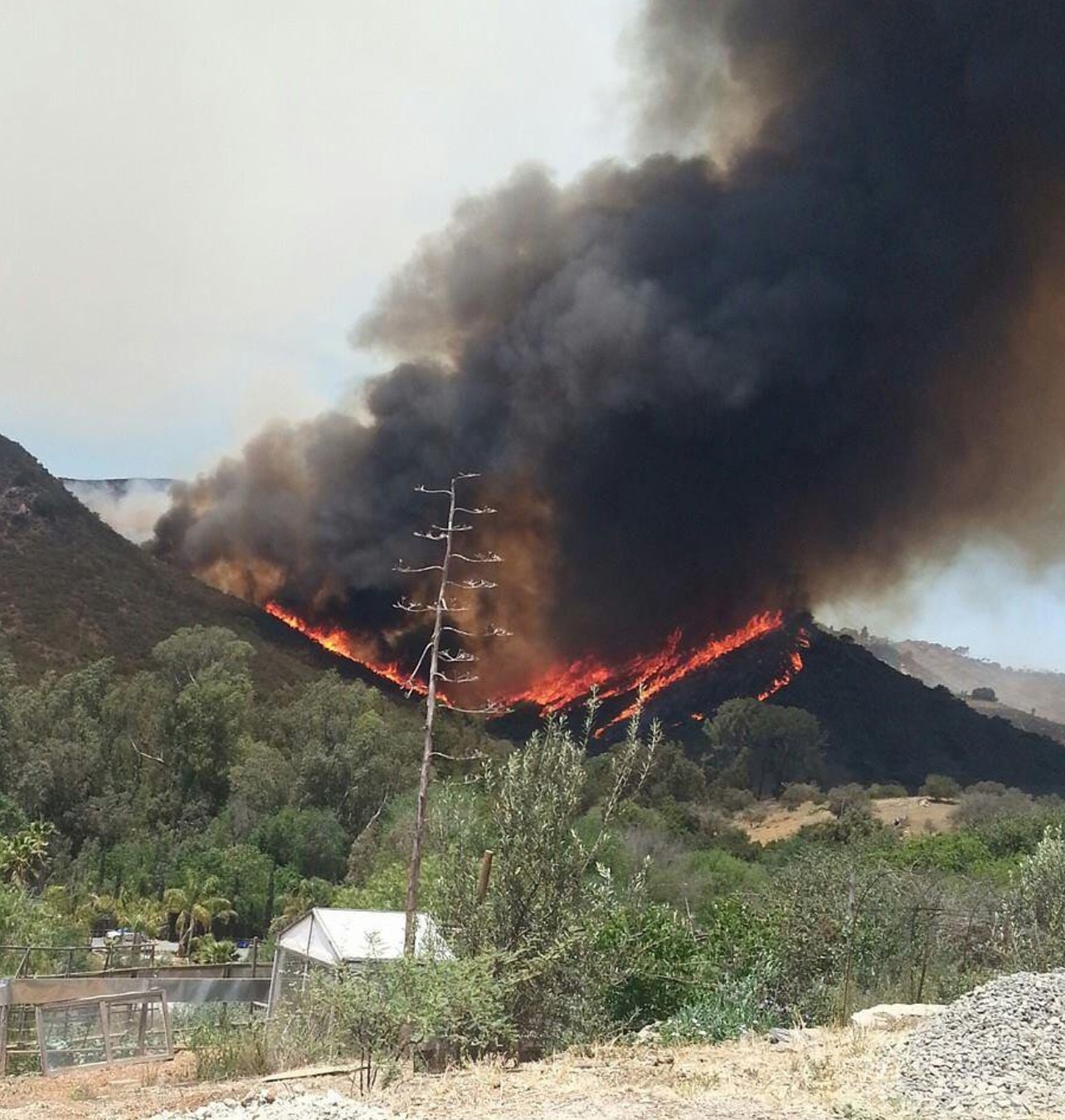
The approach of the Cocos Fire in 2014 from Harmony Grove. What started as a small brush fire on a hillside behind Cal State San Marcos exploded into a 2,520-acre wildfire that destroyed 11 single-family homes and 25 structures in Harmony Grove.
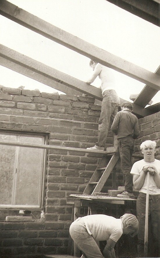
My grandfather, dad, and uncles working on construction of their Harmony Grove home in Nov 1967. Members of the family, including my grandfather, still live there today. Credit: Mark Larson


The Save Our San Diego Countryside (SOS) initiative would require a majority vote of the people any time a large scale project seeks to amend the general plan. Photo credit: S.O.S. Initiative
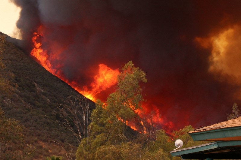
View from of the Coco’s Fire from Harmony Grove. Credit: Eric Neubauer.
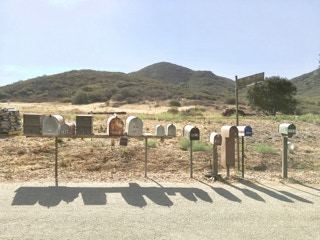
Mailbox row for some of the 60 homes that currently use Country Club Drive as their only means to escape during a wildfire. HGVS will place these residents behind an estimated 1500 additional vehicles during a fire.

The entrance to the proposed Harmony Grove Village South (HGVS) development and the single exit for the community to the intersection of Country Club Drive and Harmony Grove Rd. The road that parallels the Escondido Creek is Harmony Grove Road, which the county’s wildfire risk analysis.
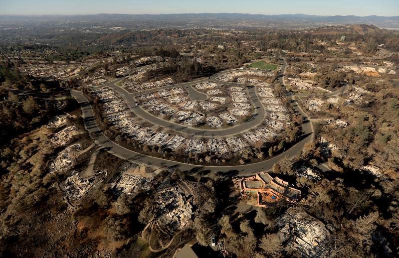
The community of Rincon Ridge in Fountaingrove, burned by the Tubbs Fire, Oct. 2017. Photo Credit: Kent Porter / Press Democrat

Current San Diego Board of Supervisors. With Dianne Jacob absent, the board unanimously approved all three General Plan Amendments on July 25, 2018.
Copyright 2020, Grow the San Diego Way